Monday, August 16, 2010

"Mobile"-izing Tech Aid

In the US and Europe, the progression of internet use went from the desktop to the mobile phone to the smart phone. And of course, maps followed this trend as sites like Google downsized their code base. In the rest of the world, however, the wired web infrastructure and computer availability lag far behind.

People Online 2008
While the internet continues to spread, there is an unexpected revolution happening from the bottom up. The relatively lower cost of mobile adoption has created a world where more human beings today have access to a cell phone than have access to a clean toilet.


Even low end cell phones can access the internet with simple browsers. This requires the developer of web applications to consider different design presentation strategies, but the payoff for people in need is definitely a game changer.

Mobile Information Platform
Now farmers can get the latest crop market news on their handheld and even text information to distribution services that then rebroadcast it to subscribers. On more advanced phones, there are inexpensive applications that utilize the web and GPS to collect data in the field and store it online.


Then the door really opens, when these repositories allow access by other applications for specific purposes, like allowing crisis responders to list requests for aid by date and location.


Access to information is power and mobile devices are leveling the playing field. The developing world is leap frogging ahead of how this progression happened elsewhere, and making the most of opportunities on smaller devices.

Friday, August 13, 2010

Mapster Mash

In the beginning there were images of static maps online. Then there were map slide shows.Then there were proprietary, interactive maps. Then there were generic, place finders. Then there were map mashups. Now there are mashups of mashups.

Coming soon to an iPhone/Android device near you, there are mobile app versions of map mashups (try this out on your handheld).This infiltration of old knowledge into new technology and information sharing will only continue to grow. When data is interconnected it becomes information and when information is made accessible it becomes a powerful tool.

Your mission, should you choose to accept it, is to sort through the maelstrom of data online, weave it into a coherant narrative, and then visualize it in a map where patterns become paths of action. And then you got that going for you.

Tuesday, August 10, 2010

Collaboration Station

Ushahidi Crowdsource Map
Yesterday I mentioned participation as a component of future maps. This is a theme that will come up often in this blog since this is where the web is headed.

People have always been subject to the rule of a few and even in that bastion of freedom, the US, the few are chosen by the majority. The minority have always gotten the short end of the stick until the advent of Web 2.0. Now the internet provides a voice for each individual and every group of like-minded folks. 

Of course every opportunity for influence brings out the "good" and the "bad" in our midst. In this conversation, however, I focus on what we can do to make things better, and specifically, what we can do with maps. As an example, here's another site where you can find a place to "fill up" your electric vehicle, courtesy of your local EVA. It's a nice way to help your fellow man, but what about when a lot of people are in need of help, as for instance during the Haiti Earthquake in January 2010. Well, there's a map for that.


By setting up a Ushahidi instance for Haiti, developers provided a way for relief workers to report where assistance was needed. At the same time, minions of geekland from around the world sifted through tweets and blogs for other reports of problems or aid needed and added them to the Ushahidi input page. Power to the People.

Monday, August 9, 2010

Sidetracked and Powerless

I had some other ideas for today's post, but found my self on The Road with Viggo Mortensen. A storm at 3 am knocked out the electricity and it wasn't on again till noon. So today I am thinking about how I love that juice running through the wires and how to keep it flowing without sucking future earth dry. I'm thinking, maybe maps would help.
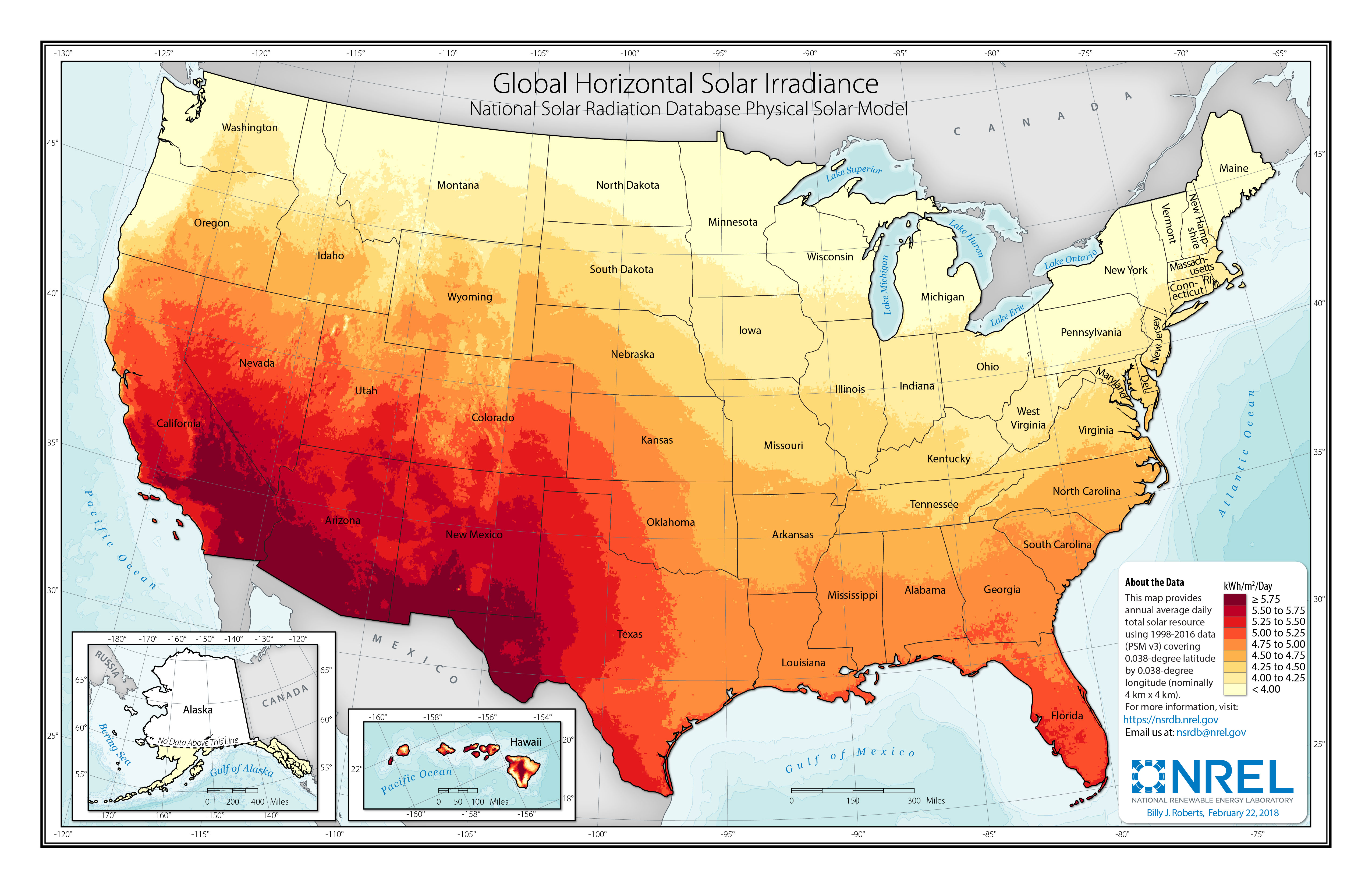
Solar resource data (nrel.gov)


One way to keep the lights on is to go renewable. Solar and wind generation, however are very location dependent. So you build a model that intakes power generation parameters and outputs generating capacity. Take the climate measurements collected across the US, feed them into the model and, voila!, you've got a capacity value for all those locations. You could visualize those values by plotting colored dots on a map, but what really drives the idea home is to generalize the points into an isopleth map.

That's OK, but how am I going to drive my car to the home improvement store to buy my solar panels? You bought an electric car, but now you're afraid to go very far from the outlet and the stations on every corner sell evil gasoline. That's when you load up a green map for your city and find the nearest charging station to where 

Seattle Green Map
 you want to go. If you live in Seattle, you could go to the Seattle Green Map page and search for "Alternative Vehicle/Fuel Station" sites. If you find new charging stations while you are out and about, you could load up the green map when you get home and add a new point for others to find. Now maps are not only accessible, but participatory and democratic. 

So now the power is back on and there are more maps to find and build. I wonder where the wind blows best for wind generation.

Sunday, August 8, 2010

Future of Mapping

The future of mapping has a lot to do with the future of our world. Fifty years ago, if you wanted to go somewhere, you might have gotten the map out of the glove compartment, unfolded it, looked up a street name in the index and then found the section referenced by the grid coordinates. Nowadays you go to MapQuest, type in the address and away you go. The computer revolution has made mapping "accessible".

The computer was made possible, in part, by ubiquitous resources, especially energy. The resources that have fueled technology have come from the world around us, and, until recently, have not been replaced. In the past fifty years we have gradually come to realize, that if you keep taking and never give back, the well will eventually run dry. So of course, one possible scenario is that we dig those folded maps out of the glove compartment, get out of the car, and walk to where we want to go, because there is no electricity to run the computer and no gas to run the car.

The forests are disappearing, the oil is disappearing, the water is disappearing. If we know where, we can mitigate, substitute, conserve. Shortages will bring conflicts and more devastation. If we know where, we can mediate and negotiate. It is fortunate that the tools we have as a result of indiscriminate consumption, can actually help us learn to live in accord with nature.

Have all the maps been made? Not by a long shot. In fact the most critical maps for our survival have yet to be made.