Thursday, October 28, 2010

Clouds are free, rainbows are extra

Sorry about that. I got distracted by life. I know you all were waiting for part two of "Power to the People". By all, I mean you, guy, with your cardboard hat, eating snickerdoodles on your bean bag chair, while Looney Tunes plays on the set. Now, where was I... Oh, yes, I was talking about how to do more with fewer resources.

As long as you dont mind putting up with a few ad boxes on your web site, or occasional down time, you can have a fully featured web presence without paying for the whole kit and kaboodle. The idea is that there are sources of digital data being streamed onto the web and you dont have to pay to access them. The current catch phrase for this digital ocean of data is the cloud.

You may have heard that an unnamed megalosaurus of a software company (if I just said Microsoft what fun would that be) is offering you a world of wondrous things in "The Cloud". And yes, it is probably all true, only dont confuse "The Cloud" with the cloud. "The Cloud" will cost you greenbacks, the cloud will cost nothing, except an occasional mind blank of ads on the periphery.

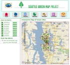
Ok, you say, now he's just ranting. So you want details. It starts getting technical here, so dont say I didnt warn you (dont you just hate apostrophes).  A stream of data in the cloud is called a web service. Everyone has agreed what a service is, so anyone can build an app to access services without a separate config for each one. What does that mean, you ask? OpenLayers is a javascript tool that lets you build a map on your site from bits and pieces of geographic data floating around in the cloud. You can add your own information to it if you want, but even that can be stored in another cloud member, an api called Google Docs. You can combine Google Docs with Google Maps (another "free" cloudite) and roll your own web map without building out your server infrastructure (see Seattle Green Map).

On top of this cloud ocean (rather than mixing metaphors again, I decided to combine them), are floating some pretty sophisticated drilling rigs. These middleware tools pull up filtered data from the ether and present it in your web site - and you dont have to pay one red cent. In the biz, we call that opensource. While these are still in their infancy, you can still have fun without paying up front. One promising data rig is GeoCommons. I built a


prototype

for one project from my own shapefile which I uploaded and from another GC layer from someone else, all overlayed on a free base layer from OpenStreetMap.

I know, not the speed you expect from the web these days, and just to warn you, some stuff just doesnt work. But as I said, we are talking about the birth of a new way of doing things, so check back in a little while. A very, little while.

Saturday, September 11, 2010

Power to the People


Back from Acadia in Maine, where earth meets sky meets sea, and where I was without my usual digital trappings. Instead I took a Boost pay as you go Android phone on which I could read emails, respond if necessary, but not do any other useful work
.

This got me thinking about information: accessing it, contributing it, and managing it. The end of last century saw the rapid rise and spread of personal computers and the internet throughout the developed world. Behind the scenes, the amount of digital information available online exploded. Adding to this, Web 2.0 interaction lead to a tidal wave of data being collected from users.

Fast forward to the 21st century. Two innovations have brought the information age to all. Mobile and the costless cloud (the what?). Who knew that the drive to provide newer, smaller, wireless devices to an insatiable digital society would produce something almost everyone in the world could afford - the mobile phone and WAP browser.

At first sight, the wap browser does not appear that functional, if you have the luxury of a PC or smart phone browser. The important thing, though, is that it allows you to be connected, and if that is all you've got, it's a great thing. Three examples of what you can do with mobile to bring information to the masses are EpiSurveyor, the Global Fire Management System, and Kiva. And, in yet another self-serving reference, the UshLo mobile site allows users to query the Ushahidi crisis crowdsourcing database for reports by date, category, and/or location. It is designed to work from most internet enabled devices, including pc's, smart phones, and phones with wap browser capability.

The next post to this blog will explain what I mean by the "costless cloud". In general, it means that developers don't have to maintain a complete server infrastructure to manage and publish digital data online.

Saturday, August 21, 2010

Cherish What Remains

Sea Cliffs, CA
Sea Cliffs, CA
The sea ebbs and flows, removing stone from the matrix of the earth. What remains are empty spaces and sometimes the arches over them. These beautiful remnants are admired by those who view them.


 Think of the sea as being over-consumption and think of the earth as being... well, the earth, then that which remains after resource depletion are wonderful fragments we should cherish.

 If we measure them and map their dimensions then we will recognize them elsewhere and find ways to preserve them.

Neighborhood Walkability, King Co, WA

When we find those old growth forests,  overgrown parklands, or washed out trails, we should show others where they are and encourage their protection, restoration, and conservation.


EarthCorp Interactive Habitat Map
And when we see something worth seeing or a place that needs attention or a source of information to guide us, we should celebrate them and share them with others.


VOAz Trail Finder Map


Thursday, August 19, 2010

Not So Lonely Crowd

In the not-so-modern world of the last century, one could easily feel isolated even in a crowd. Something has changed since then, however, adding a lifeline one can use to connect across the abyss -- welcome to the Web 2.0.

Connect, respond, interact, all at the click of a button. Haven't heard from your friends lately? Go to Facebook, see what's happening. Have something you want to get off your chest? Go to your blog and spout off. Want to make a difference in a world crisis? In the case of the Pakistan floods, go to CrowdFlower

CrowdFlower Reviewer Form
Reports sent to Ushahidi from cell phones and loaded from twitter are presented to the user for review, categorization and location assignment. The reports are then fed back to Ushahidi for final approval and addition to the online map. All the reports are then viewable by relief workers and the public in an effort to distribute as much information as possible about what is happening on the ground and where help is needed.


Ushahidi for Haiti
Welcome to the brave new world of crowdsourced information and participitory data review. Not so lonely crowd after all.

Wednesday, August 18, 2010

Across the Great Divide

Yesterday I talked about mobile phones and their use in distributing information. While top down approaches will add fuel to the fire of the digital revolution there still needs to be a way to empower those at the furthest corners of the networked earth to fend for themselves.

What if we put the power directly in their hands. By reaching out to young people who are early adopters of new technology, the closing of gaps in access to information can be accelerated. 

Mapping must also meet this challenge, and many more options are becoming available to do so. If the tools are there, what's to stop people everywhere from taking the bull by the horns and determining their own destiny? Sometimes the well must be primed. And yes there is a place for maps to help illuminate the problems and solutions when the water starts flowing.

Monday, August 16, 2010

"Mobile"-izing Tech Aid

In the US and Europe, the progression of internet use went from the desktop to the mobile phone to the smart phone. And of course, maps followed this trend as sites like Google downsized their code base. In the rest of the world, however, the wired web infrastructure and computer availability lag far behind.

People Online 2008
While the internet continues to spread, there is an unexpected revolution happening from the bottom up. The relatively lower cost of mobile adoption has created a world where more human beings today have access to a cell phone than have access to a clean toilet.


Even low end cell phones can access the internet with simple browsers. This requires the developer of web applications to consider different design presentation strategies, but the payoff for people in need is definitely a game changer.

Mobile Information Platform
Now farmers can get the latest crop market news on their handheld and even text information to distribution services that then rebroadcast it to subscribers. On more advanced phones, there are inexpensive applications that utilize the web and GPS to collect data in the field and store it online.


Then the door really opens, when these repositories allow access by other applications for specific purposes, like allowing crisis responders to list requests for aid by date and location.


Access to information is power and mobile devices are leveling the playing field. The developing world is leap frogging ahead of how this progression happened elsewhere, and making the most of opportunities on smaller devices.

Friday, August 13, 2010

Mapster Mash

In the beginning there were images of static maps online. Then there were map slide shows.Then there were proprietary, interactive maps. Then there were generic, place finders. Then there were map mashups. Now there are mashups of mashups.

Coming soon to an iPhone/Android device near you, there are mobile app versions of map mashups (try this out on your handheld).This infiltration of old knowledge into new technology and information sharing will only continue to grow. When data is interconnected it becomes information and when information is made accessible it becomes a powerful tool.

Your mission, should you choose to accept it, is to sort through the maelstrom of data online, weave it into a coherant narrative, and then visualize it in a map where patterns become paths of action. And then you got that going for you.

Tuesday, August 10, 2010

Collaboration Station

Ushahidi Crowdsource Map
Yesterday I mentioned participation as a component of future maps. This is a theme that will come up often in this blog since this is where the web is headed.

People have always been subject to the rule of a few and even in that bastion of freedom, the US, the few are chosen by the majority. The minority have always gotten the short end of the stick until the advent of Web 2.0. Now the internet provides a voice for each individual and every group of like-minded folks. 

Of course every opportunity for influence brings out the "good" and the "bad" in our midst. In this conversation, however, I focus on what we can do to make things better, and specifically, what we can do with maps. As an example, here's another site where you can find a place to "fill up" your electric vehicle, courtesy of your local EVA. It's a nice way to help your fellow man, but what about when a lot of people are in need of help, as for instance during the Haiti Earthquake in January 2010. Well, there's a map for that.


By setting up a Ushahidi instance for Haiti, developers provided a way for relief workers to report where assistance was needed. At the same time, minions of geekland from around the world sifted through tweets and blogs for other reports of problems or aid needed and added them to the Ushahidi input page. Power to the People.

Monday, August 9, 2010

Sidetracked and Powerless

I had some other ideas for today's post, but found my self on The Road with Viggo Mortensen. A storm at 3 am knocked out the electricity and it wasn't on again till noon. So today I am thinking about how I love that juice running through the wires and how to keep it flowing without sucking future earth dry. I'm thinking, maybe maps would help.

Solar resource data (nrel.gov)


One way to keep the lights on is to go renewable. Solar and wind generation, however are very location dependent. So you build a model that intakes power generation parameters and outputs generating capacity. Take the climate measurements collected across the US, feed them into the model and, voila!, you've got a capacity value for all those locations. You could visualize those values by plotting colored dots on a map, but what really drives the idea home is to generalize the points into an isopleth map.

That's OK, but how am I going to drive my car to the home improvement store to buy my solar panels? You bought an electric car, but now you're afraid to go very far from the outlet and the stations on every corner sell evil gasoline. That's when you load up a green map for your city and find the nearest charging station to where 

Seattle Green Map
 you want to go. If you live in Seattle, you could go to the Seattle Green Map page and search for "Alternative Vehicle/Fuel Station" sites. If you find new charging stations while you are out and about, you could load up the green map when you get home and add a new point for others to find. Now maps are not only accessible, but participatory and democratic. 

So now the power is back on and there are more maps to find and build. I wonder where the wind blows best for wind generation.

Sunday, August 8, 2010

Future of Mapping

The future of mapping has a lot to do with the future of our world. Fifty years ago, if you wanted to go somewhere, you might have gotten the map out of the glove compartment, unfolded it, looked up a street name in the index and then found the section referenced by the grid coordinates. Nowadays you go to MapQuest, type in the address and away you go. The computer revolution has made mapping "accessible".

The computer was made possible, in part, by ubiquitous resources, especially energy. The resources that have fueled technology have come from the world around us, and, until recently, have not been replaced. In the past fifty years we have gradually come to realize, that if you keep taking and never give back, the well will eventually run dry. So of course, one possible scenario is that we dig those folded maps out of the glove compartment, get out of the car, and walk to where we want to go, because there is no electricity to run the computer and no gas to run the car.

The forests are disappearing, the oil is disappearing, the water is disappearing. If we know where, we can mitigate, substitute, conserve. Shortages will bring conflicts and more devastation. If we know where, we can mediate and negotiate. It is fortunate that the tools we have as a result of indiscriminate consumption, can actually help us learn to live in accord with nature.

Have all the maps been made? Not by a long shot. In fact the most critical maps for our survival have yet to be made.